Problem Definition
Closed water bodies like lakes and reservoirs are under pressure due to the industrialized and intensive use for agriculture and food production. To monitor water quality, water utilities carry out periodic manual samplings at various points in their networks. Manual sampling at random locations 2-4 times per month, or even less (e.g., one time), is not sufficient to collect reliable information to monitor evolving contamination and/or incidents. In the EU, more than 1.5 million water samples are analysed manually each year, with more than 150,000 being found with high concentrations of organic matter, which may lead to a more severe contamination event. The number of these samplings is very low, and typically it is not fast enough to detect any hidden serious problem. Water utilities face huge penalties if they fail to deliver water of good quality and, therefore, an increasing number of them also use sensors to monitor their water system in real-time, measuring various parameters. Such sensors can detect incidents, e.g., by measuring exceeding contaminants’ concentration thresholds, thus alerting the water operators. However, due to their limited spatial representativity over open water surfaces, their adoption has been limited in recent years. Moreover, the cost of such devices makes it difficult for water utilities with small budgets to install a reasonable number of them. As a result, operators still largely rely on consumer feedback and manual sampling to carry out their day-to-day activities.
What we offer
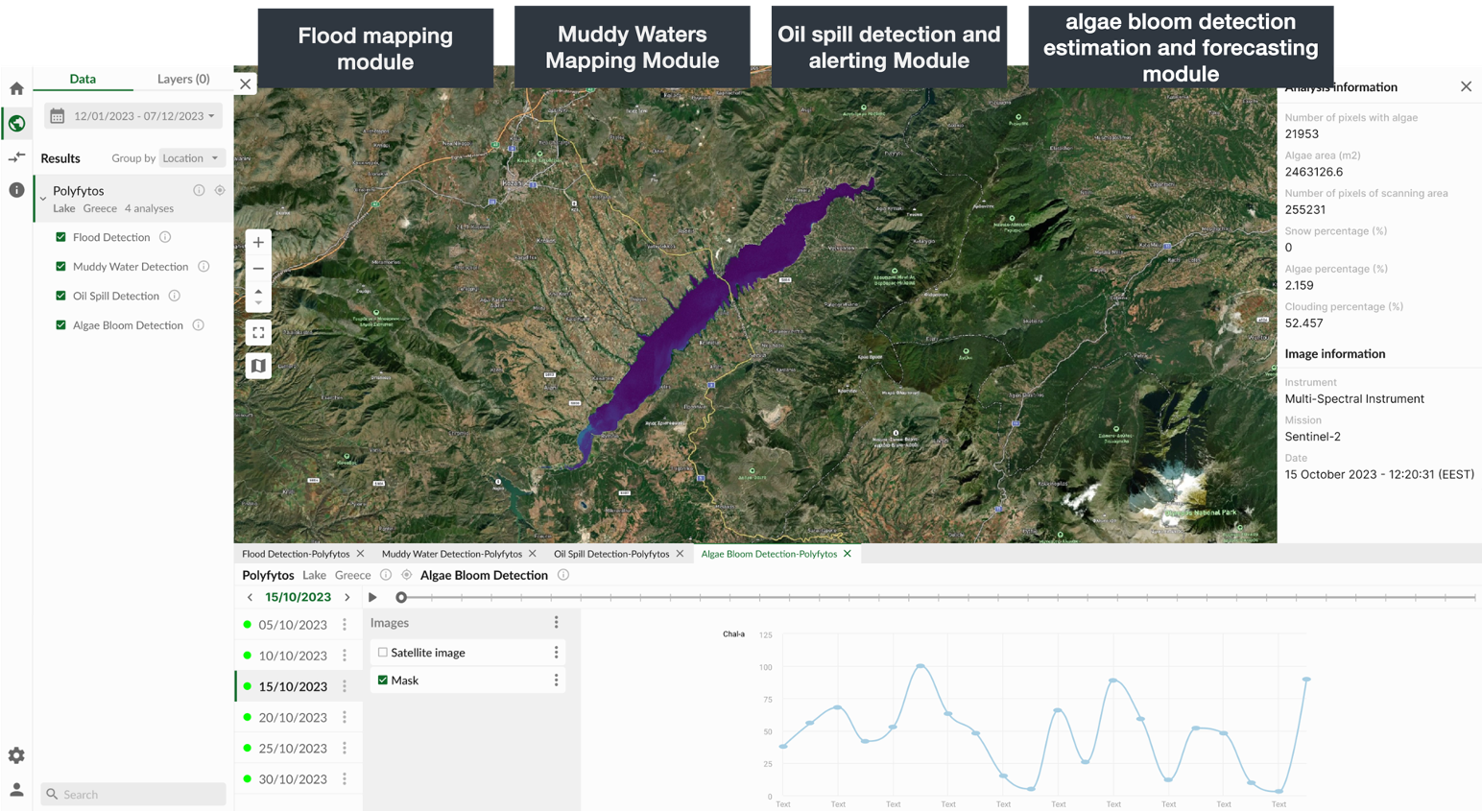
CDXi Water (former PathoSAT) aims to minimise/reduce the cost of monitoring water quality in enclosed water bodies such as lakes or reservoirs by utilizing satellite data and other available data sources (such as data from sensors, data from social media etc) in automated data pipelines and, with the use of AI/ML, to pinpoint possible areas of contamination. Such approach on multimodal content from satellite images contributes to the green transition of water quality companies, whether they are small, medium or large enterprises, public or private.
CDXi Water (former PathoSAT) is designed to identify small-scale patterns on the surface of inland waters that indicate pollution. The presence of surface formations (e.g. oil spills) in water bodies poses a significant threat to the quality of drinking water. Therefore, the early detection of these formations is of utmost importance to the stakeholders involved. Notably, the solution relies on readily available Sentinel images from the Copernicus EU program, eliminating the necessity for on-site inspections and allowing the coverage of vast geographic areas regularly.

At the moment, CDXi Water (former PathoSAT) provides the following functionality:
- Flood mapping module. Extreme flood events are usually a result of heavy rainfall in combination to other natural or human induced factors, and they have several indirect effects on water quality, due to the transportation of sediment, pollutants, or aquatic organisms, such as eutrophication, sedimentation, and the spread of invasive species, which can negatively impact water quality and ecosystem health. The module utilizes Sentinel-1 and Sentinel-2 satellite imagery, fused with georeferenced social media streams, where location appear in raw text and the module links them with geographical coordinates.
- Hydrocarbon detection and alerting module. Oil spills or hydrocarbon formations in inland waters can generally occur due to accidents during transportation, leaks from storage facilities, or illegal dumping of waste, to name a few. One of the main concerns with oil spills is the potential contamination of drinking water supplies. Hydrocarbons can give an unpleasant taste and odour to water while some hydrocarbon compounds are toxic and carcinogenic, making the water unsuitable for consumption as it can pose serious health risks when ingested. The module utilizes Sentinel-2 satellite imagery to provide its output.
- Muddy waters mapping module. Muddy water is typically caused by increased sedimentation and suspended particles, which can be the result of soil erosion agricultural runoff, or construction activities in the surrounding area and usually occur along with and after heavy rainfall events. One of the primary concerns with muddy water presence is its effect on water treatment processes. In other words, high sediment loads can negatively affect the filtration and clarification systems of the water utilities, requiring more frequent maintenance and increased use of chemicals to treat the water, which in turn raises treatment costs. The module utilizes Sentinel-2 satellite imagery to provide its output.
- Algae bloom/chlorophyll-a detection estimation and forecasting module. The module indicates the presence of Phycocyanin and Phycoerythrin by identifying reflectance and absorption discrepancies between the 550nm and 650nm wavelength bands, which are indicative of the appearance of the Cyanobacteria related pigments. The analysis considers aspects like in-water organic absorption, in-water turbidity, and spectral characteristics of each water body. The forecasting part includes the analysis of satellite image time series and the generation of the short-term expected levels of algae blooms with a Generative Adversarial Network architecture.
Impact
We have identified that the use of CDXi Water (former PathoSAT) can potentially produce a positive impact in at least 5 different areas of the UN’s Sustainable Development Goals which can be translated to positive ESG metrics for the companies that use our solution.


